Showing posts with label river. Show all posts

Thursday, October 16, 2014

Seoraksan National Park > Sokcho ~ South Korea > Day 09 (2) - 2014 October 16 (Busan, Gyeongju, Seoul, Daegwallyeong, Nami Island, Mt Seorak, Kuala Lumpur)

Seoraksan Bus Station is the last station. So you won't missed it. It's so crowded with tourists. The bus station and the entrance is quiet far. So you have to walk 10-15 minutes to the entrance. Just follow the others, because most of them is go to Seoraksan National Park.


The entrance ticket cost KRW 3.500/pax. Once we entered, we could see the beautiful autumn.


Seoraksan, also referred to as Seolsan and Seolbongsan, the mountain was named Seorak ('Seol' meaning 'snow' and 'Ak' meaning 'big mountain') because the snow would not melt for a long time keeping the rocks in a permanent state of white. In November 1965, the Seorak Mountain district was designated as a Natural Monument preservation area. Afterwards in December 1973, it was designated as a park preservation area, and in August 1982, as a Biosphere Preservation District by UNESCO.

The park is spread across 4 cities and counties: Sokcho, Inje, Goseong and Yangyang. The highest peak is Daecheongbong; to the east is OeSeorak and to the west is NaeSeorak, which is divided again into North NaeSeorak and South NaeSeorak. North NaeSeorak is composed of Bukcheon, which flows to Ingyecheon and Baekdamcheon streams. There are numerous valleys in NaeSeorak. Follow the Baekdamcheon valley where all the streams meet and you will reach Baekdamsa Temple, which is known for its beautiful scenery. Upstream there is Gayadong valley and Suryeomdong valley, and past Yeongsiam and Mangyeongdae there is Madeungryeong ridge (1,327m) that leads to Seorakdong.

Follow Suryeomdong valley and you will reach Waryong and Ssangpok waterfalls. Further up is Bongjeongam (1,224m sea level). Once you arrive at Daecheong peak you can view the magnificent mountain range. The sunrise viewed from here is spectacular and should not be missed. South NaeSeorak directs the valley from Oknyeotang area to Hangyeryeong. Daeseung Waterfall north of Jangsudae is the most beautiful site of NaeSeorak, which is 88m high. South of Yongdaeri valley is the twelve fairy bathing spring, Oktang Falls, and Yongtang Falls, along with several other traditional relics.

Credit: VisitKorea

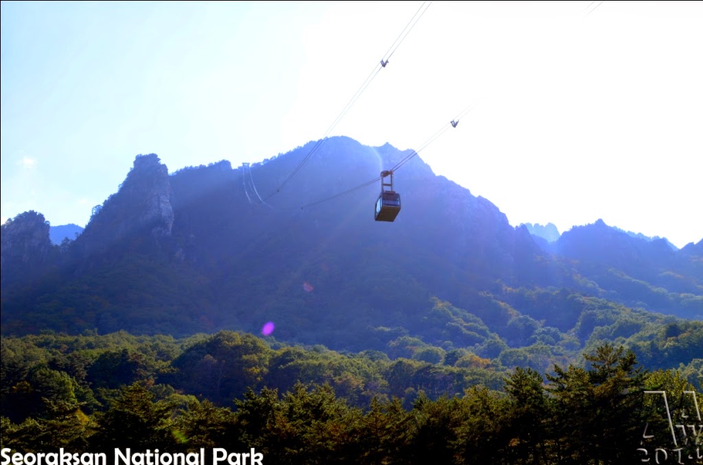
We bought the cable car ticket first. And we have to queue. There's the time schedule in there, which show what time the next cable car.

I got 15:45 cable car.


The cable car cost KRW 9.000/pax. We wait for approximately 2 hours. While waiting, we walk around the cable car area. In the behind cable car's building, there's a river with amazing scene. There's also a bridge to some attraction place (I didn't remember).

behind the cable car's building

the river


the bridge


If you want to explore more, stay for 1 / 2 nights in here. I see that there's a cabin inside the Seoraksan National Park. You can try to sleep in there, so if you want to watch sunrise, you could ride the cable car early.


Friday, May 16, 2014

Pangandaran > West Java ~ Indonesia > Day 02 > 2014 May 16

Wake up at 04:00 to watch sunrise at East beach. Too bad, it's cloudy, and the sunrise didn't full.


The East beach side, there's so many stan. You can sit and enjoy the scene.


After the sun was rise, we go back to hotel to eat breakfast. Then at 9 o'clock, we went to Citumang Body Rafting. I heard this place a few times, and some of my father's friends have already went there and they said it's so fun.

Me and my brother has meet some agent in the east beach, they said it cost IDR 100.000 if they book from Pangandaran. But we decided to see the location first, and book in there.

The journey took about 30-45 minutes. Don't worry, there's the sign of the place while on road, so you won't get lost. The route was in the middle of the journey to Batu Hiu Beach.

Arrived there, there's 2 car parking. The first one is where we go. It's the finish point for the rafting. The 2nd one, is the start point. It cost IDR 75.000 if we directly book from the location. If your group less than 10 people, then they will give you 1 guide which also help you take picture. They are proffesional, I use my pocket camera which is not water resistant, but he can use it well without touch the water.

We have to walk approximately 1km barefoot. Then arrive at the 2nd car parking. There's a sign "Welcome to Citumang Body Rafting". Then we arrive at the cave. You can entering the cave, but it's dark. We didn't entering it, but only took picture in front of the cave.

The flow near the cave was really strong. They provided rope to help us.

The first obstacle is 3 meters waterfall. We have to jump in there. There's no other way. Don't worry, the buoy help you to floating. And the guide will take care of you.


There's 3 waterfall. The first one approximately 3 meters. The 2nd and 3rd, only 1/2 meters. It's fun, but after the 3rd waterfall, it started to boring. We only follow the flow until the irrigation part, then entering small river which there's a thousand of little crab. It's tickles. But it's fun, especially if you came here with large group.

After almost 1 hour, our rafting end. Then we went back to Pangandaran to eat lunch. After the activity, we really feel hungry.


Those are the fresh seafood that we choose, guess what will it become?


There's a famous dessert in Pangandaran, it's called Es Podeng.


Then we back to hotel for resting.

In the afternoon, we go to the beach.


After play a while at the beach, then at 17:00 we go back to hotel then go to dinner. There's a special fish in the restaurant. It shark.

But we didn't eat it. Our dinner:


After dinner, we stroll around to shopping, then back to hotel to sleep. Today is tiring day.

Tuesday, September 10, 2013

Tour at Chao Phraya River (แม่น้ำเจ้าพระยา) by Boat > Bangkok ~ Thailand < 2013 August 12 (2) > (Bangkok - Ayutthaya - Kuala Lumpur)

Time for boat touring the Chao Phraya River. It's private boat, maybe only for 10-15 people.

The Chao Phraya (แม่น้ำเจ้าพระยา) is a major river in Thailand, with its low alluvial plain forming the centre of the country. It flows through Bangkok and then into the Gulf of Thailand.

Credit: http://en.wikipedia.org/wiki/Chao_Phraya_River

We road the boat at the pier in front of The Grand Palace. I didn't pay attention of the pier number.

There is Chao Phraya Express Boat, that serve at public tranport. You can see the schedule and fares in here: http://www.chaophrayaexpressboat.com/en/home/

Here's some scenery that we can took on boat.


The Bangkoknoi Aroma Museum

Royal Barge Museum


We drop in here for a while to eat some snack